Rockingham Driving Test Routes
Real turn-by-turn test routes throughout Western Australia
 Download Free!
Real turn-by-turn test routes throughout Western Australia
Download Free!
Practise REAL
Rockingham test routes.


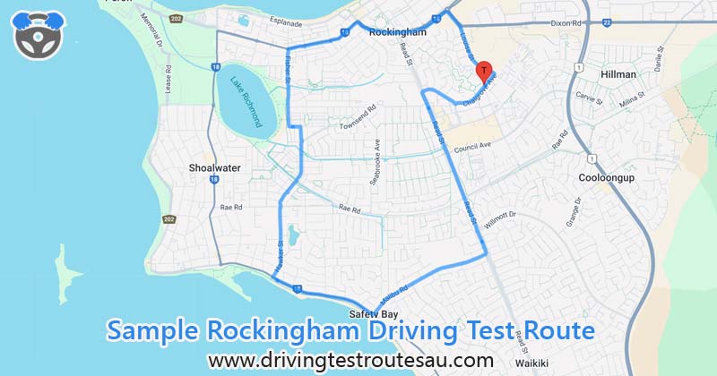
18.85 mins
Route Duration12.69 km
Route Length1 / 5
Route Number| # | Instruction | Distance | Duration |
|---|---|---|---|
| 1 | Head northeast on Chalgrove Ave toward Louise St | 0.19 km | 1 min |
| 2 | Turn left onto Louise St | 1.02 km | 1 min |
| 3 | At the roundabout, take the 1st exit onto Patterson Rd/ |
0.34 km | 1 min |
| 4 | At the roundabout, take the 2nd exit and stay on Patterson Rd/ |
0.73 km | 1 min |
| 5 | Head west on Patterson Rd/ |
0.16 km | 1 min |
| 6 | Turn left onto Parkin St/ Go through 2 roundabouts |
0.99 km | 1 min |
| 7 | At the roundabout, take the 1st exit onto Fisher St | 1.02 km | 2 mins |
| 8 | Head east on Fisher St toward Dominion Way | 0.10 km | 1 min |
| 9 | Turn right onto Caprice Pass | 0.18 km | 1 min |
| 10 | At the roundabout, continue straight onto Belgravia Terrace | 0.54 km | 1 min |
| 11 | At the roundabout, continue straight onto Hawker St Go through 2 roundabouts |
1.30 km | 2 mins |
| 12 | Turn left onto Safety Bay Rd/ |
0.07 km | 1 min |
| 13 | Head southeast on Safety Bay Rd/ |
1.29 km | 1 min |
| 14 | At the roundabout, take the 1st exit onto Malibu Rd | 1.64 km | 2 mins |
| 15 | At the roundabout, take the 1st exit onto Read St | 0.16 km | 1 min |
| 16 | Head north on Read St | 0.14 km | 1 min |
| 17 | At the roundabout, take the 1st exit and stay on Read St | 1.67 km | 3 mins |
| 18 | Head north on Read St toward Swinstone St | 0.20 km | 1 min |
| 19 | Turn right onto Leghorn St | 0.49 km | 1 min |
| 20 | Turn left onto Chalgrove Ave | 0.46 km | 1 min |
DOWNLOAD THE APP FREE!
As a key arterial road in Rockingham forming part of State Route 18, it has a number of roundabouts and connects to several local roads, making it an important part of the test. Remember when approaching the roundabouts to slow down, check for traffic from the right, and clearly signal. Since it’s a busy road, be prepared for lane changes and merging traffic.
An extension of Patterson Road that features more roundabouts, and is a great place to practice smooth navigation through intersections. You’ll notice a mix of commercial and residential properties, meaning pedestrian crossings and driveway exits are common. Watch for vehicles pulling in and out, and always slow down near pedestrian crossings.
A wide, high-speed road that runs along the southern edge of Rockingham. Unlike the smaller residential streets, this road has multiple lanes and a higher speed limit, so you will need to keep a consistent speed while maintaining your lane discipline.
A busy local road that passes through commercial areas and connects to major roads such as Safety Bay Road and Malibu Road. It’s often filled with buses, so anticipate sudden stops. If you see a bus indicating that it’s pulling out, be prepared to give way. Also, since Read Street runs near shopping centres, watch out for pedestrians crossing the road.
37 McNicholl Street
Rockingham
WA 6168
Phone: 13 11 56
By car:
Google Maps
On foot: Google Steetview
Total Routes: 5 (0 routes, 5 mocks)
Note: Book appointments in advance for both assessments and tests to avoid long waits.