Caboolture Driving Test Routes
Real turn-by-turn test routes throughout Queensland
 Download Free!
Real turn-by-turn test routes throughout Queensland
Download Free!
Practise REAL
Caboolture test routes.


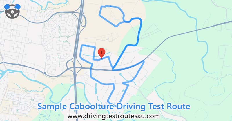
35.00 mins
Route Duration14.06 km
Route Length1 / 5
Route Number| # | Instruction | Distance | Duration |
|---|---|---|---|
| 1 | Head | 0.00 km | 1 min |
| 2 | Head east Partial restricted usage road |
0.21 km | 1 min |
| 3 | Slight right Restricted usage road |
0.49 km | 2 mins |
| 4 | Turn left onto McNaught Rd Restricted usage road |
0.11 km | 1 min |
| 5 | Turn left onto Pasturage Rd | 0.44 km | 1 min |
| 6 | Continue onto McNaught Rd | 1.01 km | 1 min |
| 7 | McNaught Rd turns slightly left and becomes Pasturage Rd | 0.84 km | 1 min |
| 8 | Turn left onto Bribie Island Rd/ |
0.94 km | 1 min |
| 9 | Turn right onto Hickey Rd | 0.98 km | 1 min |
| 10 | Turn left onto Beachmere Rd | 0.17 km | 1 min |
| 11 | Turn right onto Jocelyn St | 0.72 km | 1 min |
| 12 | Turn left onto Lawrence St | 0.01 km | 1 min |
| 13 | Head northwest on Lawrence St toward Jocelyn St | 0.36 km | 1 min |
| 14 | Turn right onto Ann Maree Dr | 0.55 km | 1 min |
| 15 | Turn left onto Beachmere Rd | 0.94 km | 1 min |
| 16 | Continue onto Aerodrome Rd | 0.16 km | 1 min |
| 17 | Turn left onto Lear Jet Dr | 0.86 km | 2 mins |
| 18 | Head east on Lear Jet Dr toward Concorde Pl | 0.28 km | 1 min |
| 19 | Turn right onto Aerodrome Rd | 0.36 km | 1 min |
| 20 | Turn left onto Piper St | 0.26 km | 1 min |
| 21 | Head east on Piper St toward Auster Ct | 0.20 km | 1 min |
| 22 | Turn right onto Skyreach St | 0.37 km | 1 min |
| 23 | Turn left onto Pasturage Rd | 0.78 km | 1 min |
| 24 | Pasturage Rd turns slightly right and becomes McNaught Rd | 0.44 km | 1 min |
| 25 | Head north on McNaught Rd toward Evans Dr | 0.56 km | 1 min |
| 26 | Continue onto Pasturage Rd | 0.44 km | 1 min |
| 27 | Turn right onto McNaught Rd Restricted usage road |
0.50 km | 2 mins |
| 28 | Keep left Restricted usage road |
0.50 km | 2 mins |
| 29 | Turn right Restricted usage road |
0.26 km | 2 mins |
| 30 | Turn right Restricted usage road |
0.11 km | 1 min |
| 31 | Turn left Restricted usage road |
0.18 km | 1 min |
DOWNLOAD THE APP FREE!
A major arterial road that connects Caboolture to the coastal areas and often features steady traffic and higher speed limits. Be mindful of traffic at intersections, particularly when turning onto Hickey Road, as this can require quick decision-making and clear signaling.
A quieter road that transitions into Pasturage Road, offering a mix of straight stretches and slight curves. This road is ideal for practicing smooth steering and maintaining proper positioning within your lane. Keep an eye out for restricted usage sections, as these areas may have limited visibility.
A scenic route that features varying speed limits, which makes it an excellent road for practicing speed adjustment and adherence to signage. Pay attention to intersections like Jocelyn Street and Ann Maree Drive, where turning requires clear signaling and good control.
A central point featuring light industrial areas and quieter stretches. It’s a great spot to demonstrate controlled starts and stops, particularly near Lear Jet Drive or Skyreach Street. Watch for trucks or large vehicles entering or exiting driveways.
Piper St
Caboolture
QLD 4510
Phone: 13 23 80
By car:
Google Maps
On foot: Google Steetview
Total Routes: 5 (0 routes, 5 mocks)
Note: Closed on public holidays.
Note: Motorcycle testing not available; contact a Q-Ride provider.